Thursday, April 3, 2014

Tuesday, April 1, 2014
Weekly Blog Maps
1) https://www.cia.gov/library/publications/the-world-factbook/
The CIA world factbook has a world map where you can click on a continent which takes you to the countries in that continent and can get all the information about that country. I chose this map because I would like to work in the Geography department for the CIA.
2) https://blogger.googleusercontent.com/img/b/R29vZ2xl/AVvXsEhTtfGHAFDtnsSRQK07ArbCoeTNrC_LgiC4W23cFM9m284XNsVqauRLWxqROrJkD3WthakyP0H3wM7u2xbwhpLX9HAC4N1c9dx8antp3gGlas5LDhjnSO4LEQGbdAisMmLm2CfLXCUMhgzj/s1600/MajorFiresAnimated.gif
This was an awesome map that is flip book style showcasing major fires as a result of nuclear power plants. The colors were used very well!
3) http://www.timemaps.com/store/timemaps/2012/4/500bc0202.jpg
Whenever I think of timeline maps I think of History subjects, so that's why I chose this as my example.
4) http://www.stadiumphysiosteo.com/uploads/image/JEUX%20Majeurs/Sotchi_2014/Sochi_Olympic_Venues.jpg
This is a map of the past Sochi winter Olympics where they show the different venues and what sport is located in that venue.
5) http://gisweb.pwcgov.org/webapps/countymapper/
Prince William has a map that you can turn layers on and off to view different things.
6) http://www.nws.noaa.gov/images/national_forecast.jpg
I think weather maps are a good idea for motion tweens because it involves the isometric lines moving across the map.
7) https://blogger.googleusercontent.com/img/b/R29vZ2xl/AVvXsEgqi0qGe7ggaMVLGasJT5e3yCMKibUEBvZ-9_2VHmhOPvvldC9vKdfsMp9K1p3Et3osYvNxKa13bfheG2UJ8e-9X3Pkb43_p4aiJb6Tbu6H7yJNB3bDhRUc2rHJi069BD6fsqFeVF6PvWE/s400/map.jpg
I utilized Google shape tween maps and found another blogger who had taken this class previously and had a clean shape tween of Operation Barbarossa.
8) http://www.androidtapp.com/wp-content/uploads/2010/01/Google-Sky-Map-Splash-Screen-200x300.jpg
Google Sky Map has a splash screen before proceeding to the map.
9) http://i31.tinypic.com/xds4t0.jpg
Of course I gotta go with a Google Map image because all of their maps consist of panning and zooming.
10) http://www.vidiani.com/maps/maps_of_north_america/maps_of_usa/detailed_3d_map_of_manhattan.jpg
I chose this because it was a cool 3-D map of the city of Manhattan. It looks kind of vintage or something that a planner would come up with to propose something with the city. I liked it a lot!
11) http://breathingearth.net/
This is such a cool interactive map showing where at in the world, how much carbon dioxide you are breathing, how much is being emitted and what the population is in that country.
The CIA world factbook has a world map where you can click on a continent which takes you to the countries in that continent and can get all the information about that country. I chose this map because I would like to work in the Geography department for the CIA.
2) https://blogger.googleusercontent.com/img/b/R29vZ2xl/AVvXsEhTtfGHAFDtnsSRQK07ArbCoeTNrC_LgiC4W23cFM9m284XNsVqauRLWxqROrJkD3WthakyP0H3wM7u2xbwhpLX9HAC4N1c9dx8antp3gGlas5LDhjnSO4LEQGbdAisMmLm2CfLXCUMhgzj/s1600/MajorFiresAnimated.gif

This was an awesome map that is flip book style showcasing major fires as a result of nuclear power plants. The colors were used very well!
3) http://www.timemaps.com/store/timemaps/2012/4/500bc0202.jpg

Whenever I think of timeline maps I think of History subjects, so that's why I chose this as my example.
4) http://www.stadiumphysiosteo.com/uploads/image/JEUX%20Majeurs/Sotchi_2014/Sochi_Olympic_Venues.jpg

This is a map of the past Sochi winter Olympics where they show the different venues and what sport is located in that venue.
5) http://gisweb.pwcgov.org/webapps/countymapper/
Prince William has a map that you can turn layers on and off to view different things.
6) http://www.nws.noaa.gov/images/national_forecast.jpg

I think weather maps are a good idea for motion tweens because it involves the isometric lines moving across the map.
7) https://blogger.googleusercontent.com/img/b/R29vZ2xl/AVvXsEgqi0qGe7ggaMVLGasJT5e3yCMKibUEBvZ-9_2VHmhOPvvldC9vKdfsMp9K1p3Et3osYvNxKa13bfheG2UJ8e-9X3Pkb43_p4aiJb6Tbu6H7yJNB3bDhRUc2rHJi069BD6fsqFeVF6PvWE/s400/map.jpg

I utilized Google shape tween maps and found another blogger who had taken this class previously and had a clean shape tween of Operation Barbarossa.
8) http://www.androidtapp.com/wp-content/uploads/2010/01/Google-Sky-Map-Splash-Screen-200x300.jpg

Google Sky Map has a splash screen before proceeding to the map.
9) http://i31.tinypic.com/xds4t0.jpg

Of course I gotta go with a Google Map image because all of their maps consist of panning and zooming.
10) http://www.vidiani.com/maps/maps_of_north_america/maps_of_usa/detailed_3d_map_of_manhattan.jpg
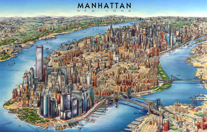
I chose this because it was a cool 3-D map of the city of Manhattan. It looks kind of vintage or something that a planner would come up with to propose something with the city. I liked it a lot!
11) http://breathingearth.net/
This is such a cool interactive map showing where at in the world, how much carbon dioxide you are breathing, how much is being emitted and what the population is in that country.
Final Project Proposal
For my final project, I am going
to make a map about my trip to Hawaii from when I graduated high school. I selected this as my topic because it’s
something that is personal to me; I loved Hawaii and it was special to me
because it was my present from my parents to me! The island that we went to was Maui. While we were there we saw a lot! We drove up
the road to Hana (which if you get car sick, be ready!). we also saw the ocean
of course, a luau, natives cliff diving, my dad and I went snorkeling and saw huge
sea turtles, but not much dolphins, which I was sad about.
The audience of my map would be anyone who wants to travel to Hawaii, travel agencies could use them, or anyone who just wants to view it! The type of visualization that I am envisioning for this map is maybe some panning and zooming, rollover buttons/ pictures.
Data sources:
An example that I found that Professor showed in class was this link: https://www.dropbox.com/s/mv0uzw2a1hz5vnz/Finalproject4.swf someone did a rollover map where you click on the images and it takes you to a map and you can rollover the words/pictures. I’m going to go somewhat in that direction but I want to add some pictures of what I saw and that we took when we were there to add a personal touch. http://www.hawaiivtmaps.com/bigislandCMI/index6.html : this site shows an interactive map where you can click on the island and it directs you to what’s on that island. http://www.mauijoes.com/mauijoeslogos/mp_maui.jpg : this link is of the type of style that I’m aiming for.

My schedule:
1) Get the basics
started such as the base map
2)
Design- pictures and
such
3)
Add the rollover
buttons
4)
I’ll see where I am
when I get to this point
Some
obstacles that I see happening are scripting, I’ve had some trouble with it for
a few of my maps and I definitely can tell that it is going to be a problem
when I get to that. I’m thinking that I will
get the image of Maui from Google Earth, so hopefully everything goes smoothly!
Thursday, March 20, 2014
Tuesday, March 18, 2014
Operation Barbarossa
I had quite a few troubles with this lab..But here's the final product! I also just realized that I did not change the width and height, resulting in the black background being much larger than it should be. I tried to re-size the symbols, but if I fixed one, then others would morph and it didn't look right; so I sized them the best that I could to fit right on the map.
Sunday, March 9, 2014
Interactive maps example
http://webdesignledger.com/inspiration/16-inspiring-examples-of-interactive-maps-in-web-design
These are cute interactive maps because they play music in one map and are creative. One map in particular is interesting called, "50 Problems in 50 Days", all of them are cool to look at so click on the site!
These are cute interactive maps because they play music in one map and are creative. One map in particular is interesting called, "50 Problems in 50 Days", all of them are cool to look at so click on the site!
Required post for the Sochi Olympics
http://speedendurance.com/2014/02/11/idashboards-best-sochi-olympics-tracking-medal-count/
This site shows the total medal count for each country that participated in the 2014 Olympics in Sochi. It's a pretty cool interactive map, you should check it out!
Also, the reason I couldn't attach the actual picture of the map was because the link to the address wouldn't work for the URL to post the picture, boo!
Subscribe to:
Posts (Atom)